Drones help and do good. They are used worldwide by companies, organizations, researchers and citizens in various uses. Here are some examples of areas where UAV (Unmanned Aerial Vehicle) does something really good for humankind and for the planet. The sky is definitely not the limit.
Anti poaching and curbing wildlife crimes
Drones do not just help scientists observe and keep track of endangered animals; they can also help protect these threatened species from poachers. Even where poaching is strictly banned and considered a serious crime, poachers break into national parks and kill animals, contributing to the illegal (and expanding!) wildlife trade industry. As a reaction to this slaughter of both wildlife and the people responsible to protect it, SmartPlanes have been delivering drones to the World Wildlife Fund (WWF) in Tanzania. And using drones has proved to be an efficient way to detect poachers and to protect and monitor the wildlife.
Wildlife monitoring
In a world where more and more animal species are on the verge of extinction, drones can be used to monitor animal populations in the wild, especially endangered ones.
Search and rescue (SaR)
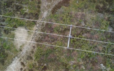
When an accident occurs, whether it is a devastating avalanche, a drowning incident or free-climbing gone wrong, Search and Rescue (SaR) teams might need to scan vast areas in search for evidence of victims. They need information and real-time imagery to be able to make informed decisions and save time. For this purpose, drones can be used in order to fly predefined search patterns and collect various types of images captured from an aerial perspective.
Forest fire control
Wildfires are a permanent threat to several regions around the world, and global climate change is adding to the number and severity of these events. From an environmental point of view, UAVs are becoming an incredibly useful tool for firefighters, especially those who have challenging, seemingly impossible task, of controlling wildfires. As wildfires are notoriously unpredictable, with many firefighters suffering serious injuries and even dying in their struggle to contain them, this is also great news for people working within firefighting.
Medical emergencies
Throughout the developing world, where there is a lack of adequate transportation and supply chain infrastructure, access to lifesaving and critical health products is many times hampered by the so-called last-mile problem. This is the inability to deliver life-critical medicine to rural or remote locations. Using UAVs to deliver first aid to these areas can help save the life of people in need of medical attention.